
Selection of images from the Accessible Photography YouTube Channel.
You may be aware that there is a YouTube channel called Accessible Photography. The channel was set up to show that photography was not solely for fit and active people. There is little need to hike 10 miles to get a picture, nor climb a mountain. In the vlogs, I try to show where I am and how easy it was to get the image. However, maybe I don’t convey that very well all the time. So I have taken a selection of pictures from recent vlogs and tried to explain the ease or the relative difficulty.
In future I will add at least one image from every new video/vlog and discuss accessibility here.
To see the exact location (where I remember it) copy the first or second set of numbers and paste those into google maps search box.
Click the magnifier icon and the location will be shown to you.
The first set of letters and numbers are proper map co-ordinates, the second are google co-ordinates.
If a walk is required to that location I will mention that in the description.
You will be able to see on the map the likely place I parked or started my walk in from.
For all in this section you can click the image and it will take you to the relevant Video on YouTube.

Cherry Blossom - Dollar
I managed to time my visit to Dollar to photograph the cherry blossom perfectly. The blossom was fantastic! The only negative was that I could only make it there on the weekend, so it was pretty busy with people. However, I managed this shot with no one in the scene. The next issue was the sun coming out after I packed my camera kit away. For the video, I also had problems with the radio mic failing to record despite having battery power left. I know now not to go under quarter power!
I was also using the Nikon D850 for the first time in a very long time. I took it out in the summer last year for a portrait shoot, but I think that is the only actual use since I fell ill at the end of September 2022. That also caused a few problems as I had to remember how to use it properly again. At least 90% of my work is done in manual, so all I had to do was find which control wheel did aperture and which did speed and which way to turn the wheel!
Nikon D850
Nikkor 24mm - 70mm f2.8
Shot at:
62mm
f11
1/40s
ISO 100
Location
56°09'49.9"N 3°40'16.5"W
What3Words - https://w3w.co/visa.incur.unionists
April 2024

Woodland Damage
I took a short walk in a local woodland, looking for compositions and exciting scenes. This fallen Tree covered in moss drew my attention because it has character, texture, and differing light. I love moss wood, especially when it is almost iridescent and glowing in the sun.
This was taken with my lightweight Nikon Zfc and kit lens. I am pleased with this camera as it captures details quite well. I make mistakes with it, and it shows quickly, so I do have to take my time and ensure the right settings are in place to get what I want.
Nikon Zfc
Nikkor 16mm-50mm f3.5-6.3 (Kit lens)
Shot at:
21mm
f7.1
1/250s
ISO 1600
Approximate location
56°04'32.1"N 3°30'38.5"W
What3Word https://w3w.co/smothered.less.body
February 2024
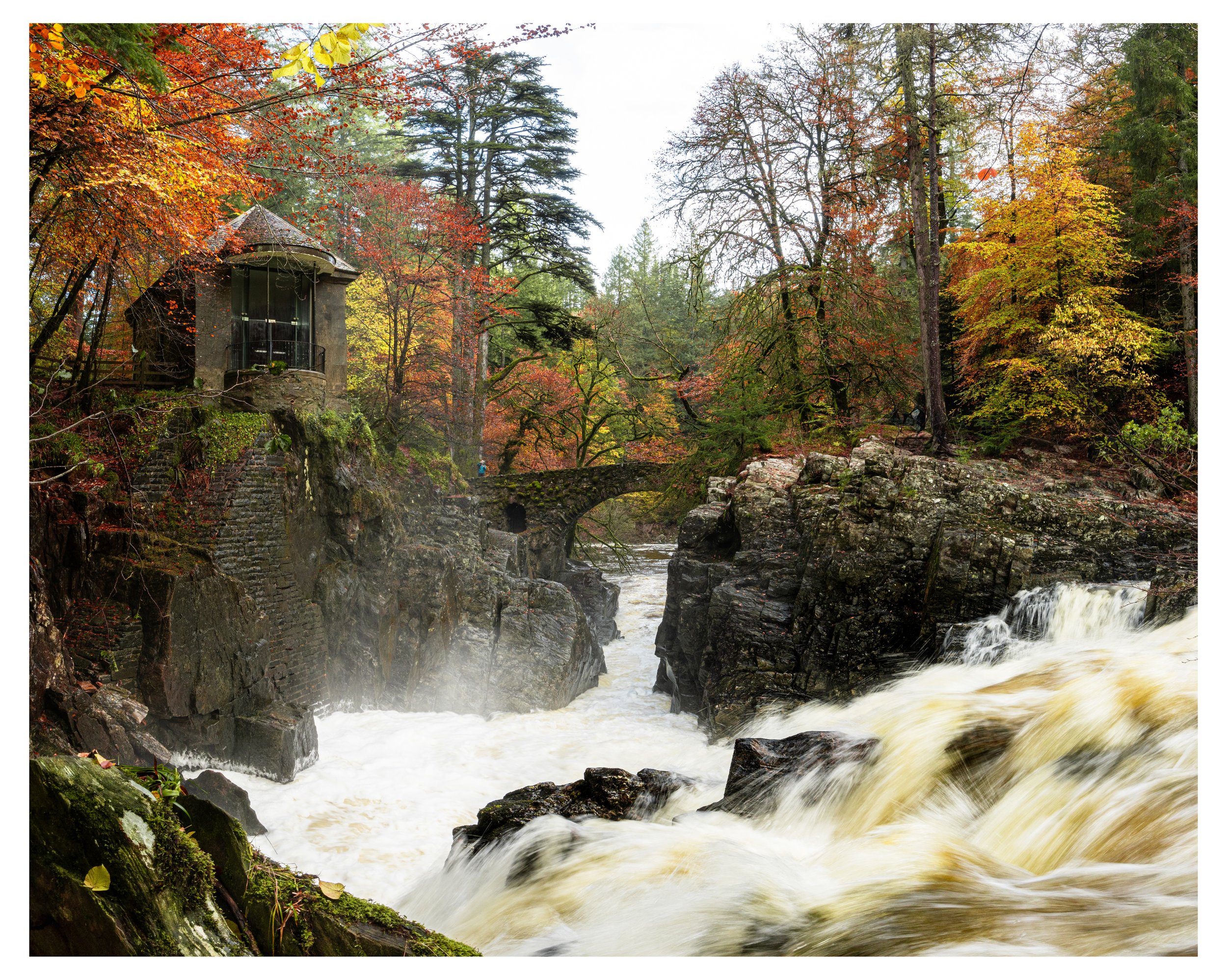
Wild Water and Autumn Scene
This is the Hermitage again. I just had to come back in Autumn especially after days of heavy rain. What a place to see, and easy to access as well. Just off the A9 and a short walk from the car park on well worn paths. A bit of a step down to here, but well worth it.
I had taken images with my 7Artisans 12mm f2.8 lens, but something was not right. I could not get a clean image. I suspect the vibrations of the torrent beside me. I switched to the kit lens and shot this at 16mm on the vertical four times. The images were then stitched to create one lovely large image.
location
56°33'27.2"N 3°36'59.1"W
56.557605, -3.616322
What3Words ///touches.margin.numeral
November 2023

Fungi
In the video, I wander in my local woodland, seeking out fascinating Fungi. There is a lot out there, but I cannot show it all, and not all is photogenic.
The approximate location on What3words is ///encodes.blanket.pickup

River Coupall Waterfall
This is one of the most popular shots in the area of Glencoe. A lovely waterfall, a birch tree and the Buachaille Etive Mòr in the background. What’s not to like?
This was the secondary location as the main view had very little water at the small waterfall. I am sure as the autumn and winter move on the falls will fill. This involves a short walk across the moorland. That can be very water-logged and boots or wellington boots are highly advised. Drive off the main Glencoe road down to Glen Etive. At the first lot of trees you come to there is a small area to park. Do so with care, remember others will want to use the same area and note, there is a severe drop into the river on the right-hand side. Wal back across the road and walk through one of the two small gaps in the bushes. That will take you on to the open moor. Walk straight ahead following the obvious route others have taken and you cannot miss the two points to get a classic view. By all means explore further up stream to find other compositions.
Nikon D850, with Nikon 14-70mm f2.8
set at 64 ISO, 14mm, 1/10sec, f16
The location where the image was taken: Use the lower two sets of numbers in Google Maps. Cut and paste!
56°38'52.2"N 4°52'01.3"W
56.647822, -4.867024
What3Words. ///lousy.risks.think
August 2023

Skyfall Waterfall
I am sure it has a proper name, this lovely little waterfall on the river Etive, now marked on Google Maps as Skyfall Waterfall despite it not actually appearing in the film. Well, not directly, as the famous image of Bond and “M” standing beside the Aston Martin looking down the Glen does show the location. If you know the area, you know that they are looking towards the falls, but they are just not quite visible to them from their vantage point.
At this time, this location is my number two accessible spot for Photography. My Number Three spot is shown in my “Touched by Light” Gallery. (Editing page to indicate that) Unfortunately I lost all usable video footage due to corrupted files in my GoPro, so there is currently (Sept 23) no video from there. Above you will find my Number one location.
Why is is this number two? Mostly because it is not such an iconic image as number one, but also it is tricky to get to if you are not very mobile. Number 1 location isn’t super easy either, but after a step up from the road it is fairly flat ground all the way to the viewpoint. With this location there is an area you can park, just opposite the near by bridge. I would suggest walking up the road (EAST) to the passing place. There you will see a feint track leading to the water. It should bring you right to the access way down to the rock i used to take this image. Take care it is uneven. Either drop down and up to the rock as Duke did, or rock hop up over and don to the main rock area.
Nikon D850, with Nikon 14-70mm f2.8
set at 64 ISO, 14mm, 1/50sec, f18
The location where the image was taken: Use the lower two sets of numbers in Google Maps. Cut and paste!
56°37'08.6"N 4°56'14.0"W
56.619061, -4.937213
What3Words. ///awakening.ultra.repeating
August 2023

Sgòrr Dhearg above Loch Leven
This was an easy shoot for me—just a few meters from my caravan. I didn’t even leave the campsite. After walking Duke and allowing him a morning swim, I came back with the camera kit to capture the lovely morning light on the mountain across a very calm Sea loch.
As you see, I hardly moved position and took several images. I could have swung around and taken more, but my videos are long enough already.
For those interested, the campsite is called Invercoe, and it can be found just across the bridge from Glencoe Village on the road to Kinlochleven. I liked it so much that I am considering using it for long weekends to do more photography in Glencoe. It just depends on my fitness and if my recurring ME complicated by Long Covid will let me do the trips I want.
Nikon D850, with Nikon 24-70mm f2.8
set at ISO100, 56mm, 1/320sec, f5.6
The location where the image was taken: Use the lower two sets of numbers in Google Maps. Cut and paste!
56°41'12.5"N 5°06'26.7"W
56.686796, -5.107407
or What3words ///comedy.moves.power
September 2023
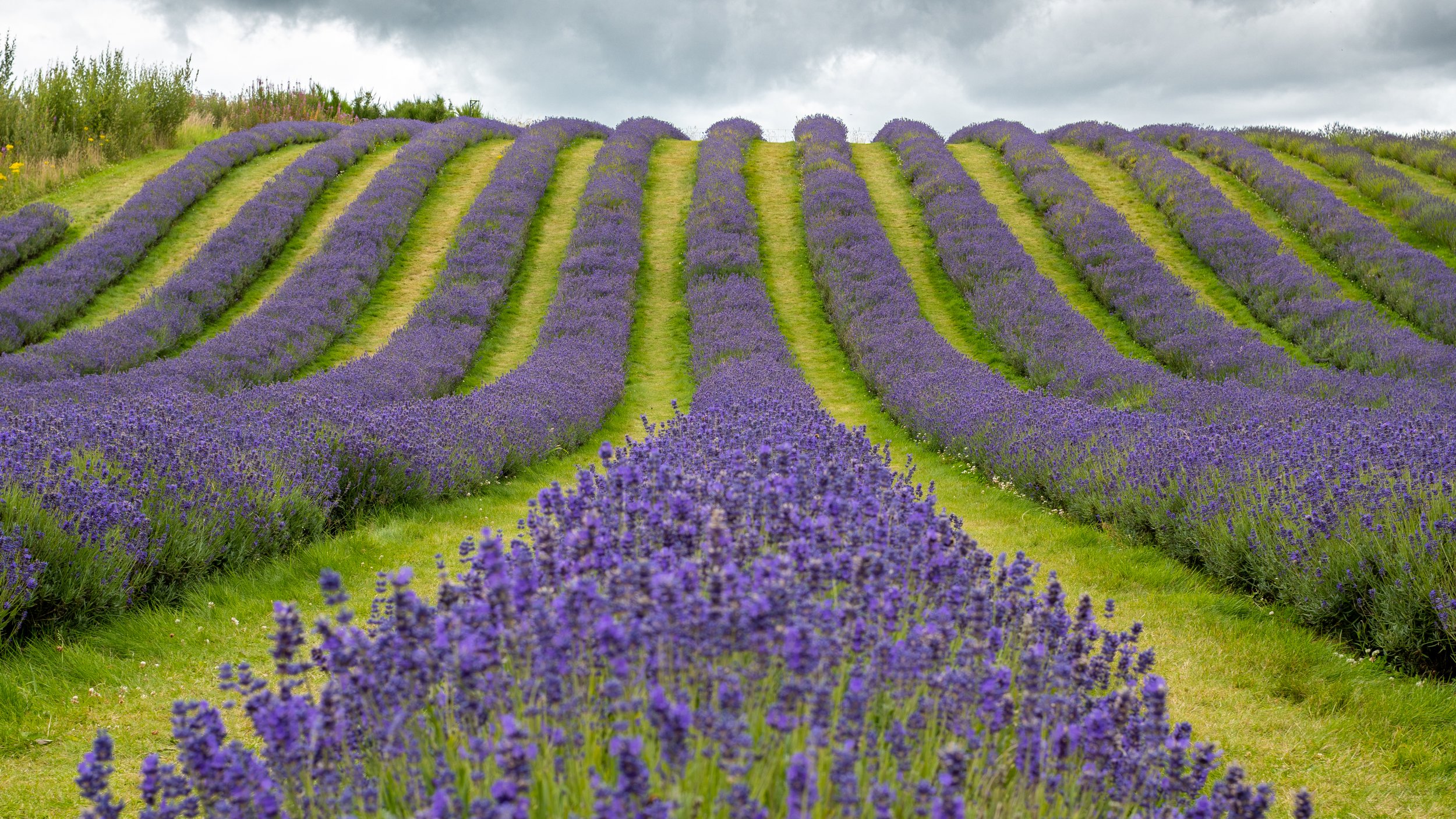
Lavender Fields of Scotland.
I was surprised to hear we had Lavender fields in Scotland and more so to hear I could drive there in half an hour. Rather than describe the place myself, I will Cut ‘n Paste from the Scottish Lavender Oils website:-
Scotland's lavender farm is truly a must-visit summer destination. We produce essential oils for our perfume brand, Pellegrini Irwin. Located amidst the lush Kinross-shire countryside of Central Scotland, our lavender farm embraces its surrounding beauty, providing an opportunity for lavender enthusiasts to get up close and personal with their favourite scent and flower. With its stunning scenic views, it is no surprise that Scotland's lavender farm has become one of Scotland's most Instagrammed and visited summer venues. Visitors can explore the rows of lavender plants while soaking in the captivating views throughout the sprawling rows of lavender. Whether you're looking for some peace and quiet alone among nature or for a photoshoot amongst picturesque backgrounds, our farm is sure to be the perfect place for a spectacular summer experience!
I enjoyed my afternoon despite the noise from excited tourists. I arrived around 2 pm and stayed until the back of Four. By that time, on a Monday, I almost had the place to myself. I advise avoiding the weekend if you want to enjoy the place without lots of people around. The area is easy to walk on and wheelchairs can move around, either with help or with motors. The inclines appeared to be no problem to a motorised wheelchair when I was there. fyi wheelchair users get free access.
I experimented with three lenses. The kit lens that came with the Nikon Zfc, a 7Artisans 12mm for wide shots and the Artlab imitation Nikkor 50mm lens from the 80s. It may be an imitation, but it is good. A solid metal and glass lens that produces crisp colourful images. Just a touch of blur in the corners, but I quite like that. It’s how I remember lenses from that period.
Nikon Zfc, with Artralab "NONIKKOR" 80s style 50mm f1.4
set at ISO200, 50mm, 1/250sec, f16
The location where the image was taken; Use the lower two sets of numbers in google maps. Cut and paste!
56°13'14.2"N 3°23'34.7"W
56.220610, -3.392974.
What3Words. ///extremes.skyrocket.between
July 2023
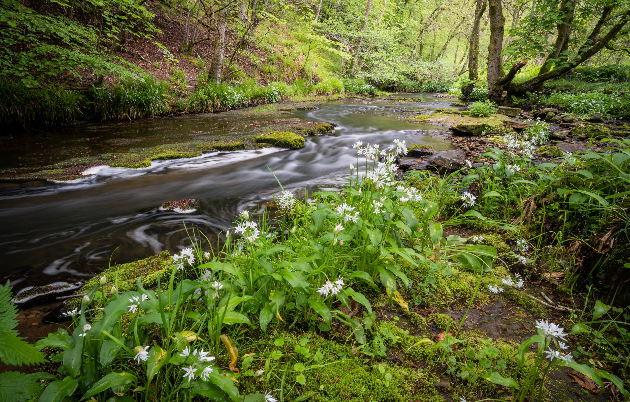
Stream and Wild Garlic.
The idea was to locate a scene of Wild Garlic and new ferns visible from a high path. Unfortunately, my normally excellent sense of direction failed me, and I followed the wrong stream quite a distance before giving up on my quest. I opted for whatever I could find. Unlike other videos on YouTube, I could not find great swathes of Garlic nor a nice path lined with the stuff. What I had was clumpy and overrun with weed. Maybe I was just a little late in my quest. Maybe a week earlier, and the weeds would have been lower.
The scene I found was beside the stream, where I instantly knew a slower shutter speed would make the water all nice and blurry and be a great backdrop to the sharp edges of the garlic flower. I am almost happy with the result, though you can see where my dog Duke walked through the scene munching grass and leaves.
The lens is a cheap 7Artisans 12mm and it does a good enough job. Some slight blurriness in the top edges I notice, but thats just how our eyes see things.
Nikon Zfc, 7Artisans 12mm f2.8 lens
set at ISO125, 12mm, 4sec, f16
There is no need for the location. I don’t expect you to try and get there.
May 2023

The Rocks and Harbour of Puerto de la Cruz, Tenerife.
This was taken looking down from the Batería de Santa Barbara. The crashing waves I found great to watch, but preferred the wash-away look after the wave had gone over the rocks. I spent far to much time around this small harbour. I should have explored more, but that’s me, I take my time and take too many pictures in one place. At least I managed a few shots before I got to the harbour and Batería. Click the image to see the video. Feel free to skip ahead a few minutes to get to the picture taking. ;-)
(I have edited out a fair bit of me talking to the camera, especially at the beginning of the video. Hopefully, it will improve retention levels. Many came to the video by searching Puerto de la Cruz and found me waffling about my health. not great!)
Nikon Zfc, Nikon z16-50mm f3.5.- 6.3 kit lens
set at ISO320, 18mm, 1/60sec, f13
The location where the image was taken; Use the lower two sets of numbers in google maps. Cut and paste!
28°25'06.3"N 16°32'58.6"W
28.418427, -16.549599
What3Words. ///loaders.sunrises.sturdily
February 2023

The Jacobite
The video is subtitled " Stay calm, Don’t Panic " because I was not ready for the train coming. The light had changed, and the exposure was wrong. I had to adjust the camera settings, which meant dropping the camera down to get an exposure setting for the shade. As a result, I am not using the best settings. The shutter should have been faster, and the front of the train would have been crisper than it is.
Accessibility. If you use the location info and Google maps, you will see I am at the side of a road. A dead-end road, so there is minimal traffic. The other photographer was further down to my left, which I liked as I could get the tree in as balance and another excellent feature for the image.
The black and White version is on this website. Look in the black and White gallery. I actually prefer that version.
Nikon D850, Nikon 24-70mm f2.8 lens
set at ISO320, 28mm, 1/100sec, f16
The location where the image was taken; Use the lower two sets of numbers in google maps. Cut and paste!
56°52'59.3"N 5°41'40.6"W
56.883133, -5.694608
What3words. ///depth.lazy.sheds
SEPTEMBER 2022

The Old Boat of Caol
September sees me back at the North West Coast of Scotland. I was there for 3 full days and only this one was dull and wet. No worries though, some of the best images are taken in poor conditions. I have numerous pictures of this boat, I had even been down in the afternoon and taken more. What I wanted was a really moody shot and the half dark with rain clouds over Ben Nevis is exactly what I wanted.
A blend of two exposures to ensure the shadow detail of the boat came out and the sky did not burn out. Like my Boats on Mull image, people have commented on the “oil painting” look. i say thank you because thats what I am after. Texture in the images is what I like and that includes cloud. It may not be to everyones taste, but I like it and that is really what matters.
Nikon D850, Nikon 24-70mm f2.8 lens
set at ISO400, 70mm, 1/4sec, f11
Location where image was taken;
56°50'27.6"N 5°07'03.4"W
56.841001, -5.117622
What3words. ///stint.gasping.somewhere
SEPTEMBER 2022

Nordkapp
In July I visited Nordkapp / North cape. This view point is called Skarsvågrevva and the red buildings below belong to the Scandic Nordkapp Hotel, with Nordkapp Camping buildings in front.
The rainbow is genuine, not some Photoshopped effort. I have a string of images from this period all with the Rainbow in them. It just seemed to hang around for ages. Have i climbed up a hill to get this shot? Have I gone against the idea of Accessible Photography. Well, I would love to say yes, but no. The hardest part was stepping over the Armco barrier at the side of the road to get closer to the edge.
The video is in the form of a challenge from a fellow Vlogger from Hong Kong, Keith Reyes the Clueless YouTuber goes out. For the environmentalists out there that may explode at the idea of me jetting off to Norway and the far North just for a photo, well no, let me tell you a secret.
I was booked to see a concert in Oslo, then to visit friends in Alta in the far North of Norway. The idea of a collaboration came up and this planned trip was perfect for the “Challenge”. In fact the intro with me in the church yard was actually filmed a full month after I was in Nordkapp. The Scene in Alta where we decide to go to Nordkapp was filmed three days after we went there. Oh, and the Portal didn’t actually appear. lol. What I am saying is the whole episode looks like I keep moving from place to place trying to get to a monument as far North as possible. It wasn’t real, it was all artistic licence. Yes I travelled, but not just for one image.
Norkapp, I found is an area and not a single small point at the far North of Europe. We drove into the Norkapp Commune well before the Nordkapp tunnel taking us to the far North. Nordkapp is a municipality in Troms og Finnmark county, Norway. The administrative centre of the municipality is the town of Honningsvåg, where most residents live. Other settlements in Nordkapp include the villages of Gjesvær, Kåfjord, Kamøyvær, Kjelvik, Nordvågen, Repvåg, Skarsvåg, and Valan.Wikipedia
I would say, Nordkapp is an area worthy of photographic expeditions. Just from the road there where stunning views and I can only imagine what was beyond the hills we could see. The keen walking photographers would thoroughly enjoy this part of the world.
Nikon D850, Nikon 14-24mm f2.8 lens
set at ISO200, 36mm, 1/160sec, f9
Location where image was taken;
71°01'39.3"N 25°50'58.6"E
71.027589, 25.849622
What3Words. ///grand.bathtubs.smokers
July 2022

Alta Rock Art
In July I had the pleasure of visiting the Alta Museum and seeing Rock Art created between 6000 and 2000 years ago. Many thanks to Jan Dølør the Director of the Museum for the access to this location. Photography is allowed here, but you must stay on the pathways. I would say, be careful with tripods, that they don’t fall on to the rocks. Never mind damage to the camera or tripod, damage to a World Heritage Site may not go down too well.
Yes I used a tripod and set up with my widest lens 14-24mm. I wanted the rock and the moody sky in the shot. Due to the low light caused by the storm clouds rolling over the shutter speed was low, 1/25sec. I wanted as much detail as possible so had the ISO at 64. A higher ISO would have given a faster shutter speed, but being on a tripod there was no need.
When men scratched these drawings on to the rock the sea was nipping at their feet. They scratched here, some 4000 years after the ice age ended. Now close to 6000 years later the land has risen up and away from the water line. I tried to show the height, but the wave pattern makes the sea look closer than it is.
Nikon D850, Nikon 14-24mm f2.8 lens
set at ISO64, 14mm, 1/25sec, f11
Location image was taken (Approx)
69°56'55.9"N 23°10'41.3"E
69.948855, 23.178130
What3Words. ///headings.pencils.choppy
July 2022

Woodland Walk
I'm getting back out and vlogging at last. I took a wee walk in the woods looking for detail and I found this little scene. Clover and old leaves on top of a rotting fallen tree. Who knew Clover was hairy??
It is quite hard to create a vlog of good images. As soon as I head off with a vlogging camera, it becomes harder to see the really good stuff. A bit like when I go out to photograph birds I see none. So I am happy to get one relatively good shot. The depth of field could have been better.
At least I have been able to get out and take pictures though as the past few months have not been very productive. As I said in the video, lots of phone camera shots, but nothing with the big camera. Let’s hope my health continues to improve and I get out more and get some nice shots to share.
Location image taken from:-
What3Words ///briefer.column.impaired
June 2022

Hermitage
A week after my return from Iceland where I had a nasty wee M.E. episode and I am off in the caravan meeting up with friends at Dunkeld, Perthshire. This was to be my last proper Vlog for many months as my M.E. became too bad for me to do anything over my paid work and walking Duke. This post is being completed in June as I had even neglected the web site. I hope to get out and Vlog soon!
This location is the Ossian Hall at the “Hermitage”. It is a viewing platform that captures the roar of the Black Linn water fall with in its specially designed shape. There are doors on it now, but when I first visited in the 70’s it was wide open and as you walked through the entrance you were hit with the almighty roar! It is still loud if the doors are all open, but not like it was, for as you can see there is glass right up the front so less noise gets in.
I set up in a precarious position at the top of the falls. I tried various shutter speeds. The faster the shutter the more the water was frozen which was quite cool, but I wanted a bit of blur to show the movement. This one is14mm, f8, 1/20sec, ISO320, I feel f11 would have been better but I was having to raise the ISO to get the speed I wanted.
Location image taken from:-
56°33'26.7"N 3°36'53.1"W
56.557406, -3.614760
What3Words. ///deduct.office.blush
March 2022

ICELAND
This was from day one of what turned out to be a two day trip to Iceland. I do not recommend such a short visit unless you just want to stay in one place. To be fair it was a “City Break”. This was at the furthest point of our day in the car. Yes we visited a couple of waterfalls of course and they appear in the Vlog. We had planned to be pony trekking on the black sand beach, but the weather had been horrendous and the event was cancelled. This view was planned in advance. In fact I had climbed a mound behind this location to get a higher view. This though showed too much of the town of Vik, which to me fair is not exactly pretty. I came down trying different perspectives and ended up with this one from the car park. The peaks are called Reynisdrangar.
Location image taken from:-
63°25'16.0"N 19°00'10.2"W
63.421121, -19.002839
What3Words ///gymnastic.consent.fixate
March 2022

Walk towards Dumyat
Took a walk along a hillside. Not a difficult walk as the carpark is well up the hill. A little more undulating than I expected, but I was feeling good that day and managed just fine. The view down below is the Stirling University Campus and the monument on the hill is the National Wallace Monument (Braveheart).
The walk was nice with fabulous views across the Forth Valley. These views however do not alway make for good photographs.
Location image taken from:-
56°09'27.8"N 3°54'12.6"W
56.157715, -3.903500
What3Words. ///reverses.dugouts.aged
Feb 2022

Vic Spinning the fiery wire wool
In this episode I join my photography group in a spot of light paining. This is a great fun thing to do. You will though need a volunteer to swing the rope or chain. Maybe take turns so each can have a go and each get photos.
For this I opted for 30 second exposures at f10 and an ISO of 125. I will be honest it was complete guess work but it came out well. In other images, despite it being pitch dark, I have been able to bring out the snowy hills 10km away. See section “My general Work” for these.
Feb 2022

Prince’s Street, Edinburgh
An unusual place for one of my Vlogs. I think, nae, sure that this is the first ever Vlog from a city. The reason is simple, talking to camera amongst people is embarrassing and I have avoided it up to now.
I took a couple of main images and a couple of other images while on Calton Hill over looking Edinburgh. I will show the others in the “My General Work” gallery as I quite like them.
It was as expected not easy for me to talk to camera but I did so, if a little subdued. Interaction with others does show I do have some life in me ;-). The surprise was being asked for the loan of a battery. I paused just for a second to consider and said yes. Would I get it back, well you need to watch to find out.
Location image taken:
55°57'15.7"N 3°10'58.9"W
55.954363, -3.183018
What3Words. ///race.song.putty
Jan 2022

Glen / Loch Affric, Scottish Highlands
This is one of the best views in Scotland and thankfully not taken in it’s thousands. Probably due to the fairly long drive down a dead end road! The view can be seen from a monument at the top of a path from the carpark. The problem there though is a lot of the water disappears behind a mound. A muddy trail will take you to this location. Here I stood for around an hour just waiting for the right light. The weather was very variable from sunshine to flurries of snow or rain. I was happy to get what I did, especially the mountains with a covering of snow, because that was not there the day before.
Location image taken:-
57°15'59.1"N 4°59'15.6"W
57.266414, -4.987652
What3Words. ///jets.lightbulb.letter
Oct 2021

Bow Fiddle Rock
Not the usual view. I was trying to get the sunrise coming up behind the rock. Planning showed it was possible but reality said no. I would need to be standing with the Cormorants on that rock in the middle of the frame.
Accessibility for Bow Fiddle Rock views. There is no carpark. Street parking is available. The path down is just a worn track in the dirt. A sheep track type of path. The best of the tracks are up high. Careful if you head off closer to the edge. Those tracks are less used, a bit rough and can be steep or involve big steps to get up or down. Needless to say the closer to the edge the more care you should take. The track to this point where the image is taken from is up a mound on ground that is eroding away with use. The track is very close to a cliff edge. I moved further to my left and had to go into a hollow and climb back out the other side. No way was I walking the rim, it was far too close to the cliff edge. If you go in windy conditions be particularly careful. Predominant wind will be pushing you to the edge at this point.
Location
57°42'21.7"N 2°51'15.6"W.
57.706032, -2.854322
What3words. ///branded.guard.slack
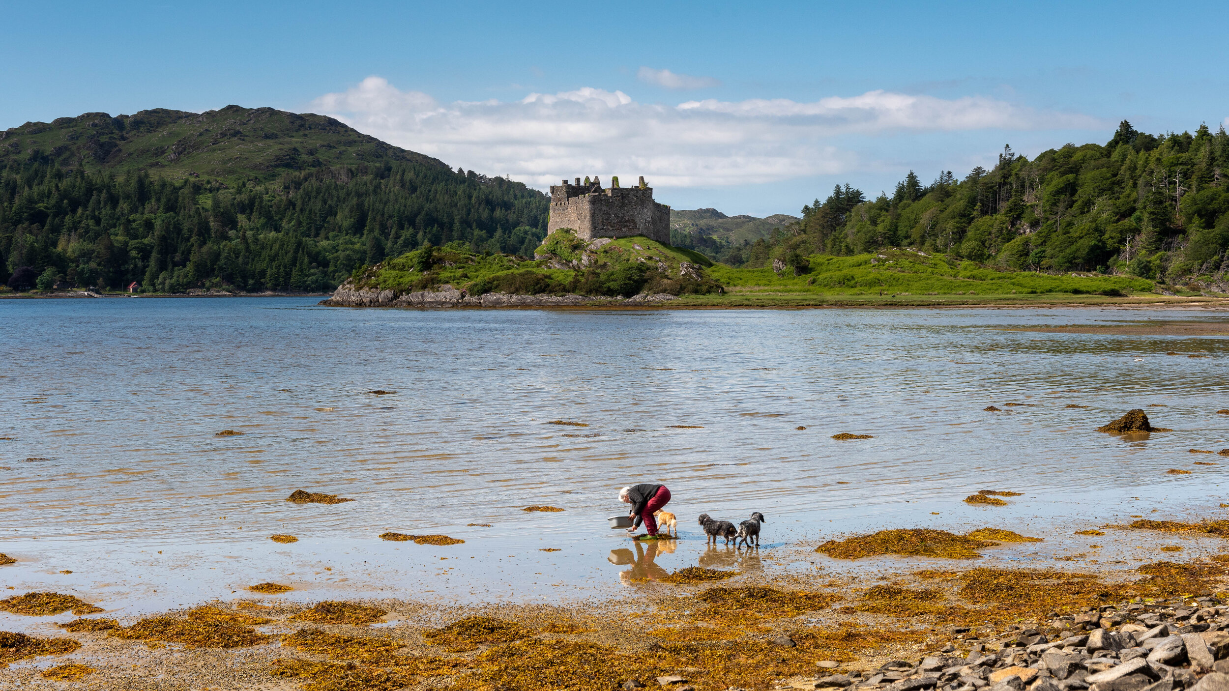
Castle Tioram
Old lady collecting Sea Eagle feathers.
Very accessible view, but road in is narrow with interesting tight corners to get round. Don’t bring a big camper this way.
Location 56°46'51.4"N 5°49'32.7"W.
56.780954, -5.825741
What3Words. ///touchy.embers.pounces

Rùm and Eigg
A small islet almost mimics the shapes of the big islands behind. I started the video saying the image would be of islands on a Scottish Summers day, which meant cloud and occasional sun. It turned out the view to the Islands was almost cloudless. Almost a Post Card shot. The place I stood for this image is tricky to get to if you are not steady on your feet or balance is an issue. I am far more careful these days than when young and then I would have leapt from rock to rock to get to where I wanted. Not now though. Of course, there are plenty other view points of the islands. You just wont get this islet in the foreground. Just a short distance along the road and there is a pull-in with stunning views over the water to Eigg and Rùm beyond.
Location:- 56°50'15.9"N 5°48'13.6"W.
56.837736, -5.803764
What3Words. ///tailwind.shorten.bicker

Ben Nevis from Loch Eil
A summer shot, no drama no mood. Some won’t like it because of that, but I do!
The location is not being divulged as I borrowed the location from a fellow Vlogger and he didn’t give away the exact location. I worked it out, checked it out and then accessed it. It was an easy walk in, but as per the Vlog I warn against fast traffic on the road and the active railway line you have to cross to get here.

The Jacobite Steam Train
A shot at an iconic steam engine, The Jacobite or Hogwarts Express. Officially this is The Jacobite Train, but for obvious reasons the owners have also dubbed it the Hogwarts Express and sell tickets to that market. There is even a Harry Potter shop on board. This is a clever way of increasing your target market from steam enthusiasts and people wanting to see the stunning Scottish Landscape to also include Harry Potter fans young and old. The reason for this being obvious is that this is the sister train (BR 45407 or LMS 5407) to that was used in the Harry Potter film and travels across the famous Glenfinnan Viaduct where Harry flew a car past the train. The actual train 5972 has been loaned to Warner Bros Films for their Harry Potter film Studio Tours. By the way both trains were built in 1937.
I have walked a short distance from the car to this location. There is ample parking at Neptune’s Staircase which is close by. I would suggest using the Banavie Locks Car Park which has a path heading towards this location. Around 120m only.
I love the combination of the old white house on one side and the signal box or bridge control tower and Ben Nevis on the other side of a fabulous old steam train. Using this location I have been able to balance the image with Ben Nevis on one side and a large tree on the other. Without that tree it would not look as good. The balance of the control tower and the house also works well. Feel free to cross the line and get the view from the other side. Especially if the sun is out as the train will be better lit.
The train made its way across the swing bridge very slowly, which makes it ideal for photography by novices. A calm day will mean excellent reflections in the canal below, but note the train does not reflect well from this position.
Location: 56°50'40.1"N 5°05'50.1"W.
56.844471, -5.097251
What3Words. ///thinnest.prancing.attaching

Iris flowers and Mountain
No, it’s not a ground breaking image, but the scene is nice. Well I think so. This was a very accessible image. With a place to park really close, and setting up at the edge of the road, you really can’t get much simpler. That is the whole idea of this web site and the YouTube channel. Easy to access images. Yes, a nice sunset would make it better. Maybe next time. But to be fair, getting a glorious day in Scotland is quite rare, so look at it as a unique capture. :-)
Location: 56°46'12.3"N 5°02'29.9"W. 56.770076, -5.041644
What3words ///claim.riders.licks

Glen Nevis
From a distinctive mound or knoll, at the side of the C1162 Glen Nevis Road, we get a spectacular view up the Glen. Although not mentioned in the video, we are looking up at the mountains Sgurr á Mhàim, Stob Choire á Mhail and Stob Bàn. The biggest of all, Ben Nevis, is to the side, so close its summit cannot be seen. I just had to get a sunny view of this location and ventured out early enough to avoid incoming cloud, but late enough for the light to flood down the steep mountain slopes. (To see that image, check out the West Coast Gallery). I then returned two days later to get this shot. Again, early, but this time before the cloud hanging off the steep hill sides would burn off. The rain had just stopped and the air was warming, which causes the forests to steam and add to the hanging cloud. Unfortunately these moist windless conditions are perfect for the Midges and clouds of those descended upon me. Not for many years have I experienced Midges as bad as this and never have I filmed a swarm so clearly. The location behind this view point was used in Braveheart for the village scenes, but we also see other areas in this image were other scenes were filmed. Other notable movies have been filmed in this Glen such as Harry Potter, Outlander, & Highlander.
Accessibility. The view is obtainable from the car, using the carpark at the location marked on Google maps as The Braveheart Film Village. If you are up to it, you can climb this Mound for a better view. There is a path and steps, but the steps are huge, so be aware.
Location: 56°47'18.6"N 5°03'23.7"W. 56.788487, -5.056594
What3Words. ///piglets.lyricism.equivocal

Castle Stalker
I spent a long time waiting for the sun to reappear having gone in moments after I arrived at the Castle Stalker View. Up at the view point which is part of a Cafe and Shop, you look down on the castle and have a view out down the coast as well. After an hour and a half I gave up waiting on the sun and found my way down on to the beach for this classic shot. It is not the easiest place to get to by car as parking is restricted. Probably due to the number of people wanting to get this view. I was lucky and got in to the Old Inn car park just before the owner closed it off. If you do get parked or can cycle in along the cycle track then this is a great view point. However, be aware the lines will be submerged when the tide comes in. If you watch the Video linked in my video then you will see Kieran Husbands in the very situation.
I was lucky. I had not planned this, it was pure luck. I also managed to get some amazing cloud to add drama to the scene and just enough sunlight coming through to make the castle pop. Had it been direct full sun then the shadows would have been far darker. I don’t know about you, but I like the soft sun light and soft shadows.
The image is three images blended. Three focus points, the immediate foreground, the waters edge and the castle. This ensures the while scene is in focus and not soft which would happen with a high f stop number like f22
Wikipedia :- Castle Stalker (Scottish Gaelic: Caisteal an Stalcaire) is a four-storey tower house or keep. It is set on a tidal islet on Loch Laich, an inlet off Loch Linnhe. It is about 1&1⁄2 miles north-east of Port Appin, Argyll, Scotland, and is visible from the A828 road about midway between Oban and Glen Coe. The name "Stalker" comes from the Gaelic Stalcaire, meaning "hunter" or "falconer". The island castle is one of the best preserved medieval tower houses to survive in western Scotland and is a Category A listed building. It stands in the Lynn of Lorn National Scenic Area, one of forty such areas in Scotland.
Location : 56°34'21.4"N 5°22'56.9"W. 56.572619, -5.382474
What3Words. ///frosted.uniforms.imparting

Isle of Mull - Old Beached fishing boats, Salen Bay
These are the famous wrecked fishing boats beached on the shore at Salen Bay, Isle of Mull. This location is on the east coast of Mull, approximately halfway between Craignure where the Ferry comes in and Tobermory, which was my first planned destination. The full name is 'Sàilean Dubh Chaluim Chille' (the black little bay of St Columba).
I had not planned on seeing these boats, but as they are right beside the road I could not resist. The fact they are so close to a road would explain why a search on line will bring up hundreds of images of them. There is a small area just off the road that will accommodate two maybe three cars. Just be careful not to drop wheels off the edge. I had to assist another photographer as she could not get her car back up over the edge. A combination of not being a good driver, her words, and a very low powered hire car. Access to the boats is good and the beach not too uneven. A simple picture from where you park may well be the best image available. As you will see from the video I tried several compositions and preferred the view shown here, from in front of my car.
Location : 56°31'12.4"N 5°57'11.5"W 56.520116, -5.953200
What3Words. ///page.maple.redouble

Gylen Castle of the Isle of Kerrera
A long walk in, for me at least. 2.66miles and then you have to walk back to the ferry.
The island is a joy to walk. It is peaceful and the scenery delightful. Get the passenger only ferry, which is located south of Oban. You then have a choice of going straight to the castle. or taking a Loop on the West side and back on the East. You can also head to the North of the Island if you so wish. Take care at the castle as there are no barriers at the cliff edges!
Location of Image: 56°22'45.8"N 5°33'23.0"W. 56.379399, -5.556391
What3Words. ///bulb.adverbs.shelving
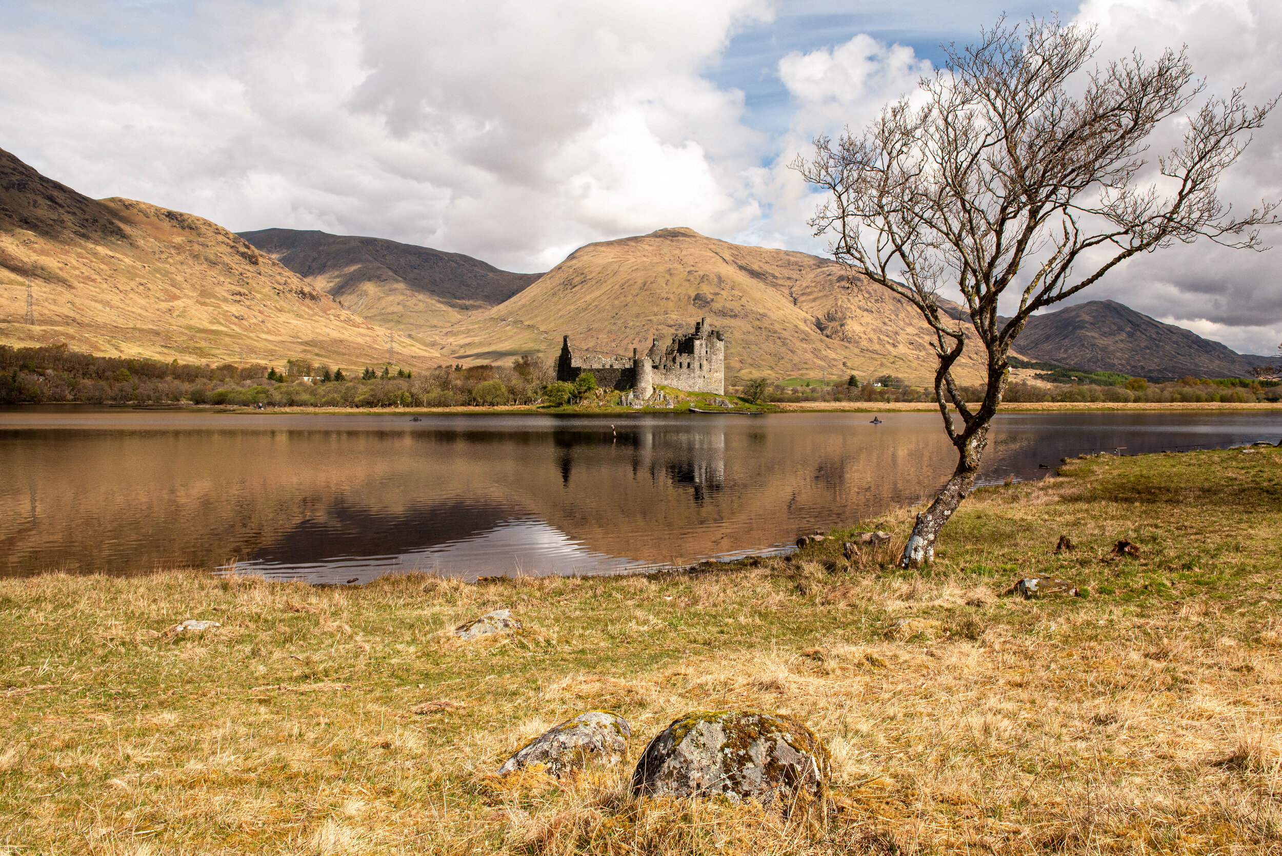
Kilchurn Castle
Not the best image ever taken of this Castle, by far. BUT, this was just a scouting trip and one day I will get this at dawn or dusk when it is at it’s best. Maybe even with some snow on the hills. You can read more about this image and others in the “West Coast 2021” section.
Location - 56°24'05.1"N 5°01'38.9w" 56.401412, -5.027464
What3Words. ///merchant.retrieves.boom

The Church. A late afternoon dog walk up to the "Catholic Church of The Holy Name" (As per the sign above the door.) I really wanted a pure white field, but forgot about the long tufts of what I think is Bog Grass. I wish I'd stopped working a little earlier as then I might have managed to get the entire Church in the sunlight. Accessibility. For me not bad at all. An easy walk from home and trudging across a snowy field is not too difficult. I certainly wouldn't want to try a long journey through conditions like that though. For anyone visiting, there is a car park at the church. To access the field, rather than climb a fence, walk to the right on exiting the car park (North) and follow the path to the point where the fence is down and has been for a number of years. Walk up and over the crest and the view will be there for you. Camera; Fujifilm XT-4. Nikon D750 for last two images. Location image was taken from: 56°04'46.0"N 3°34'14.2"W 56.079434, -3.570613

The Old House. A simple dog walk with the camera. I parked (after a very short drive) in a cafe carpark. The cafe was closed due to lockdown. Crossed the road and walked down the path which once was an access road. Now just a narrow walk way. A gentle walk past fields through the edge of a wood and up an incline to this location. 56°05'46.8"N 3°35'54.2"W 56.096337, -3.598375

A taste of the amazing Glen Affric Autumn colour. Loch Beinn a' Mheadhoin. I had planned on being here for several days, but a poorly dog saw me return home after only one day. That day had been ear marked as my Recce day, but as the sun came out I started to vlog. The colour and the reflections in the loch are just wonderful. This image is taken from on top of a Dam. There is a small car park and the access down to the dam is easy. 57°18'21.6"N 4°52'04.1"W 57.306008, -4.867814

I had three hours of light to photograph Autumn in Perthshire. I was stopping over for the night on my way to Glen Affric. I managed just a few images in the Killicrankie to Queensview area. I hope in my Vlog I show clearly how accessible everything was. Three out of four locations are from the road side and the fourth, the one shown here, is Queens View, which is highly accessible. For detail of Queens View accessibility please see the video I did a couple of months before this one. The autumn colour, even though subdued by the weather was jaw dropping. Seriously, next year, if you can, then make your way to Perthshire for wonderful colour and scenery. All the way up the A90/A9 from Dunfermline to Inverness was just spectacular. This is Queen's View location. Once there, follow the well marked path to the view point. 56°43'00.4"N 3°51'27.4"W 56.716770, -3.857602

Castle Grant, Home Farm Entrance. Taken on an evening photo trip on Speyside. I could return to this area again and again and have new content each time. There is so much to see. Here though I have taken a run in the car out of Granton-on-spey heading North and take in a couple of places of interest. If you are in the area I do suggest you go for a drive, park safely and take the pics you want. Just remember to watch for traffic when at the side of the road. You will notice in the Vlog that Duke does not appear until I am away from the roads and climbing a hill. For this image I parked on the far side of that arch where there is space to do so. Listen and watch for traffic when walking through the arch though as there is little room there. Note the lack of pavement at the side of the road. 57°21'06.2"N 3°36'32.9"W 57.351707, -3.609132

Linn Falls, Moray. This started out as a vlog about river photography in Perthshire and Speyside, but that did not pan out. I ended up concentrating on this one place. Accessibility for Linn Falls is good. There is a wide flat surfaced path all the way in with only one moderately steep incline. Parking can be done either in the Aberlour distillery (Maybe just pay that a visit first) or by the cemetery. Maybe not right in front. There is a carpark behind it. Photographs can be taken from the edge of the stream, despite what I do, so I give this a Level 1 Accessibility rating due to ease of access and good path. If you use Google maps to check out the location you will not see the path. Look North of that location and you will see the Aberlour Distillery. The path is on the East side of the stream that runs beside the Distillery buildings. Unlike some Google reviews suggest, you do not access from the Distillery! 57°27'40.6"N 3°13'34.0"W 57.461285, -3.226106

Seacliff Beach near North Berwick. Had this not been a planned day out I would have stayed at home. I was tired and feeling a bit down in the dumps. The video probably reflects that as it is not easy to Vlog when you really don't feel great. However, later on I felt so much better than I would have done had I stayed in the house. Getting out and getting good fresh air (maybe polluted by sand at times) is highly beneficial to mood and energy. Access to Seacliff beach is by car and you have to pay to get in. There is a small parking area, which we used, but found later a much larger carpark further on with better beach access. I suggest you use that. I will do my best to pin point the location of this image. Note the little harbour is further to the right and a little forward of this location and is very much worth a visit. Feel the image is a bit grainy. Yes, that's because the light level was very low and the ISO had to be raised. 2000 ISO to get a 1/250 sec exposure at f13 56°03'15.8"N 2°38'20.7"W 56.054382, -2.639079

This time I am photographing Snowdrops. Where this is taken is accessible to most people, so feel free to visit Valleyfield Woodland Park in West Fife. Access is via the village of Shiresmill and you use the Riding for the Disabled therapy centre carpark. The path in is from the carpark. A shout out to the West Fife Woodlands Trust for looking after the woods and paths. Of course there is no need to go to my location as Snowdrops are all over the countryside at this time of year (February). If you manage to find a place with lots of them then that is great, but generally patches can be found on woodland walks and parks. The video for this image was my first in 4K. It did not go with out its problems which resulted in images being cropped without me realising and text getting cropped as well. Location - 56°04'03.1"N 3°35'56.9"W 56.067530, -3.599133
Balvaird Castle in Perthshire. Where I parked was only 200m from the Fife county line. The walk to the castle was up a gentle incline on a good path. It was late afternoon/early evening when I arrived. The sun was almost down and I had to work fast to get shots in the light. However this is one of the dusk images that I really like. It is critical to get the branches and twigs in focus or the image is ruined and I feel I got that right. This image does not show the castle, just some old walls. The castle is of the Tower House variety and actually has glazed windows, so looks habitable. Please click the image to view the video to see the full castle. I do suggest visiting if in the area. 56°17'19.9"N 3°20'33.2"W 56.288867, -3.342554

Adam "Wadger Catcher" Russell and myself took a trip out to the East Neuk of Fife on a wee reconnaissance / scouting trip. Crail - Accessibility is very good. Park as close to the harbour as possible and its a short walk down. Those able to walk further, there are places to park in the village. It is worth walking through the village as you may get some nice architecture shots or even some seascape shots. The plan here was to create a "recce to final image video", but it just never happened. Therefore the video, which came out many months after filming, is a gentle reminder to finish off your projects, however little or large they may be. Please excuse my indulgence as I added a short memorial to my recently departed brother at the end. Location - 56°15'25.9"N 2°37'39.5"W 56.257193, -2.627630

Bringing in the harvest on the Machair. Machair refers to a fertile low-lying grassy plain found on part of the northwest coastlines of Ireland and Scotland, in particular the Outer Hebrides. The best examples are to be found on North and South Uist, Harris and Lewis. (Wikipedia) I took a drive round the Berneray coast in search of a monument and found this scene. This an others of the crofters bringing in the hay or silage, I am not exactly sure. I liked the tractor in heavy shadow and the sun bursting through between the clouds. I could have made this image a silhouette of the tractor and less burned out sky, but I really liked the detail I was able to get and keep the drama of the sky. I am parked at the side of the single track road on an area of cut Machair . I have walked no more than 10 meters to take the shot. Very Accessible. Location: - 57°42'22.3"N 7°12'37.2"W 57.706185, -7.210323

A new view. With trees felled, the view from the road of the loch like River Spean is now available. Check the location on Google maps, street View. As of January 2021 it still shows this view as a forest. What drew my attention was the crepuscular rays - Some people call it the "Fingers of God" or "Buddah's Rays" and even "Jacob's Ladder". Whatever you call it, they make wonderful additions to any landscape scene. I was parked a few meters away and walked back to this vantage point. The reason I walked back rather than just take the picture from the car is simple. By bringing in the curved wall, I created a leading line straight into the middle of the picture and the rays shining down. The eye is then brought back down to the right where the single trees remain. With two in line with me, the eye is brought to a fence and then back to the beginning and your exploration of the images starts again. Location- 56°53'58.3"N 4°38'40.5"W 56.899534, -4.644584

From the A86 Loch Lagan to Spean bridge. Sorry, I cannot remember the exact location. However, again, I am parked at the side of the road to get this image. The weather was getting worse, a storm was coming in and the further west I went the wetter and windier it got. These can be excellent conditions to get dramatic images though. Often I have just kept driving through bad weather. This time I had no real time line, no rush, so could stop and take pictures whatever the weather.
I joined other vloggers on a visit to Ayr and Dunure. The group of us belong to a Facebook page called "Landscape Photographers on YouTube". This was a Scottish meet up and around 8 of us managed along. Many thanks to Adam Wadger Catcher Russell for organising the day. Like other videos I do make comment as to the accessibility of the locations. This image along with the title image for this section was taken just off Shore Road, Ayr. Local knowledge from Adam being used here. It was actually a side distraction to the main reason for visiting that area and that was to see and photograph a boat wreck. The image is of the remains a groin. There are several here and maybe at one time they did help keep a beach in place, but alas, no longer. A bot of a tricky slippy set of steps to get to for this one. 55°28'20.6"N 4°38'07.0"W 55.472400, -4.635283